
Grand Turk in Liverpool
Grand Turk in Canning Half-tide Dock with Pier Head Buildings beyond

Sharing Mail Across the Globe…..
28 Dec 2012 Leave a comment
in **Cards Received, *United Kingdom Tags: Boats, Buildings, Cityscape, Lakes & Rivers, Stamps
Grand Turk in Liverpool
Grand Turk in Canning Half-tide Dock with Pier Head Buildings beyond
27 Dec 2012 Leave a comment
in **Cards Received, *Netherlands, *United Kingdom Tags: History, Map, Stamps

Hadrian’s Wall Map
Map showing the route of Hadrian’s Wall stretching from Bowness-on-Solway to Wallsend. This 84 mile length of the wall is now very popular with walkers as The Hadrian’s Wall Path National Trail.

from a Postcrosser in the Netherlands
16 Dec 2012 Leave a comment
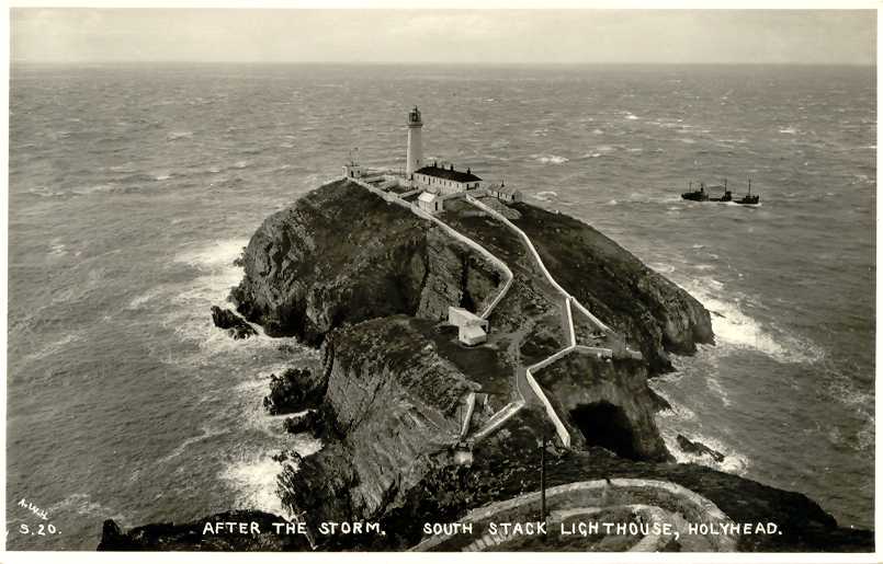
in **Cards Received, *United Kingdom Tags: Lighthouse, Stamps

South Stack Lighthouse
Goleudy Ynys Lawd, Wales
South Stack (Ynys Lawd)1809 (Daniel Alexander). Active; focal plane 60 m (197 ft); quick white flash every 10 s. 28 m (92 ft) round stone tower with lantern and gallery, attached to 1-story keeper’s quarters and service building. Entire structure painted white. Fog horn (one 3 s blast every 30 s). A photo is at right, Trabas has a great photo, Brian Mott also has a good photo, Wikimedia has many photos, Marinas.com has aerial photos, Huelse has a historic postcard view, and Google has a satellite view. The station is now a Trinity House Visitor Centre, the only one in Wales or western England north of Cornwall. South Stack is a steep-sided island off the western tip of Anglesey. The island is separated from the mainland by a narrow channel crossed by a footbridge since 1828; the present bridge, built in 1997, is the third. Visitors cross the footbridge after descending 400 steps from the parking area, and they must climb those steps on their return. Despite the strenuous climb, this is a well-visited lighthouse, one of the best known in Britain. Located about 5 km (3 mi) west of Holyhead. Site open, visitor center and tower open to guided tours (limited to 12 persons per tour, tickets required) daily early April through September (admission fee). Operator: Trinity House. ARLHS WAL-025; Admiralty A5204; NGA 5520. -The Lighthouse Directory

10 Dec 2012 Leave a comment
in **Cards Received, *United Kingdom Tags: Cityscape, Ocean, Stamps

Shanklin
Seafront and Town, Isle of Wight, UK

10 Dec 2012 Leave a comment
in **Cards Received, *United Kingdom Tags: Map, Stamps

The Lake District and Lancashire Map
Great Britian

04 Dec 2012 Leave a comment
in **Cards Received, *United Kingdom Tags: Art Card, Sports, Stamps

London 2012
Olympics – Paralympic Games

29 Nov 2012 Leave a comment
in **Cards Received, *United Kingdom Tags: Cityscape, Lighthouse, Stamps

Southwold Lighthouse
Suffolk
St James’s Green
Southwold1890 (James Douglass). Active; focal plane 37 m (122 ft); four flashes every 20 s, white or red depending on direction. 31 m (102 ft) round brick tower with lantern and gallery, painted white, attached to 2-story keeper’s house. Steve Fareham’s photo is at right, the Southwold Museum has a page on the lighthouse, Trabas has a photo, Marinas.com has aerial photos, and Google has a satellite view. Thanks to its urban location, the lighthouse was automated quite early, in 1938. Located in the center of the seaside resort town of Southwold, about 15 km (9 mi) south of Lowestoft. Site open, tower open to guided tours on weekends, Wednesdays, and bank holidays April thorugh October. Operator: Trinity House. Site manager: Southwold Millennium Foundation. ARLHS ENG-135; Admiralty A2272; NGA 1588. – Lighthouse Directory

05 Nov 2012 Leave a comment
in **Cards Received, *United Kingdom Tags: Stamps, Trains

Highland Railway Clan Class
BR 4P No 54767
Classic Locomotives of Scotland

Classic Locomotive L&YR 1093
State to accompany the postcard
26 Sep 2012 Leave a comment
in **Cards Received, *United Kingdom Tags: Birds, Stamps

Broadland Birds
Herons ~ Bearded Tit ~ Great Crested Grebe
Coot ~ Mute Swans ~ Mallard

01 Sep 2012 Leave a comment
in **Cards Received, *United Kingdom Tags: Map, Stamps

Map of Norwich
“This map shows the city centre of Norwich, within the boundaries of its medieval walls. Parts of these walls still stand.”


